


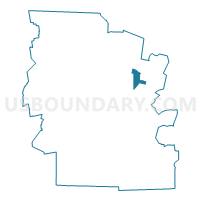
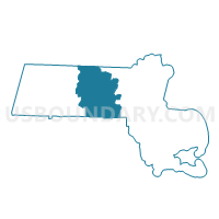
Lancaster Precinct 2, Worcester County, Massachusetts
About
Outline

Summary
| Unique Area Identifier | 595736 |
| Name | Lancaster Precinct 2 |
| County | Worcester County |
| State | Massachusetts |
| Area (square miles) | 8.15 |
| Land Area (square miles) | 8.09 |
| Water Area (square miles) | 0.05 |
| % of Land Area | 99.34 |
| % of Water Area | 0.66 |
| Latitude of the Internal Point | 42.45224860 |
| Longtitude of the Internal Point | -71.70133880 |
Maps

Graphs
Select a template below for downloading or customizing gragh for Lancaster Precinct 2, Worcester County, Massachusetts


Neighbors
Neighoring Voting District (by Name) Neighboring Voting District on the Map
- Bolton Precinct 1, Worcester County, MA
- Clinton Precinct 1, Worcester County, MA
- Clinton Precinct 4, Worcester County, MA
- Lancaster Precinct 1, Worcester County, MA
- Leominster Ward 3 Precinct B, Worcester County, MA
- Sterling Precinct 2, Worcester County, MA
Top 10 Neighboring County Subdivision (by Population) Neighboring County Subdivision on the Map
- Leominster city, Worcester County, MA (40,759)
- Clinton town, Worcester County, MA (13,606)
- Lancaster town, Worcester County, MA (8,055)
- Sterling town, Worcester County, MA (7,808)
- Bolton town, Worcester County, MA (4,897)
Top 10 Neighboring Place (by Population) Neighboring Place on the Map
Top 10 Neighboring Unified School District (by Population) Neighboring Unified School District on the Map
- Wachusett School District, MA (41,346)
- Leominster School District, MA (40,759)
- Nashoba School District, MA (19,542)
- Clinton School District, MA (13,606)
Top 10 Neighboring State Legislative District Lower Chamber (by Population) Neighboring State Legislative District Lower Chamber on the Map
- Thirty-Seventh Middlesex District, MA (43,412)
- Fourth Worcester District, MA (40,759)
- Third Middlesex District, MA (40,656)
- Twelfth Worcester District, MA (40,378)
Top 10 Neighboring State Legislative District Upper Chamber (by Population) Neighboring State Legislative District Upper Chamber on the Map
Top 10 Neighboring 111th Congressional District (by Population) Neighboring 111th Congressional District on the Map
- Congressional District 3, MA (664,919)
- Congressional District 5, MA (662,269)
- Congressional District 1, MA (644,956)
Top 10 Neighboring Census Tract (by Population) Neighboring Census Tract on the Map
- Census Tract 7131, Worcester County, MA (8,055)
- Census Tract 7191, Worcester County, MA (7,808)
- Census Tract 7161, Worcester County, MA (7,558)
- Census Tract 7092.02, Worcester County, MA (6,829)
- Census Tract 7151, Worcester County, MA (4,897)
- Census Tract 7162, Worcester County, MA (2,820)
Top 10 Neighboring 5-Digit ZIP Code Tabulation Area (by Population) Neighboring 5-Digit ZIP Code Tabulation Area on the Map
- 01453, MA (40,883)
- 01510, MA (13,606)
- 01564, MA (7,808)
- 01523, MA (7,582)
- 01740, MA (4,897)
- 01561, MA (330)